
It all started with a rather arcane question posted online by Creuset, a friend of mine, “Do you guys think these two photos are of the same tree? Current day version on left, 1999 version on right.”
In response to her question, I offered to go down to Leakin Park to shoot some video and take some stills. The next thing I know, I was involved in a puzzle that has held my attention for these last few weeks. I responded to Creuset on a Wednesday night. Thursday of that same week I was trudging around in Leaking Park near Latitude 39°18’6.51″N, Longitude 76°41’59.32″W. In addition to my camera and tripod I was carrying a metal detector. The funny thing is I still had no real idea what I was truly looking for. I had missed the detailed instruction Creuset had sent by email. She had even tried to walk me through what she wanted via a skype call while I was in the valley, but reception was terrible.
That evening September 1st, when she and I were comparing notes on the shots I had taken that day, I finally got a hint into the puzzle she was trying to solve. During our conversation, she offhandedly said “Well if you think you know were where the body was actually buried…” or something to that effect. To which I replied with all the misplaced confidence and condescension so typical of me, “I know the correct location!” After all, I had been to the very same spot where Buddemeyer and the video crew had been in 2016 when they filmed his recollections of the incident.
It was right about then that I learned what a great teacher Creuset is. In the most non-confrontational manner, she led me through a series of discrepancies that caused her to question whether the 2015 tree was the same one from the 1999 video when Gutierrez and Buddemeyer were in the same video together. As Creuset went through her list of discrepancies I was amazed at how easy it had been for me to dismiss these same inconsistencies, which I had seen while filming at the burial site. For instance, if you watch the 1999 Buddemeyer/Gutierrez video of the log carefully, you’ll see, the significant areas of rot apparent in the burial log, which is missing in the 2015 log.
Besides overlooking the missing rot on my first trip to the morbid valley, I had easily discounted the amount of ground clearance between the burial log shown in the 1999 Buddemeyer and the one in 2015. “Perhaps it is just erosion”, I had used as a convenient excuse. Still, other variations included the diameter, and the relationship of the log to other enduring landmarks in the Dead Run Valley. All these things together made one thing crystal clear by the end, of our conversation. I knew I would not be satisfied until I had another look at the burial ground in Leakin Park. In fact, I was anxious to go the very next day. Only one thing was stopping me. I was scheduled to have my right knee replaced with a new version made of titanium and plastic. That was not the sort of appointment I could reschedule. Fortunately, the knee replacement went better than expected, so just 21 days after surgery, I was back in the park.
On my return, I was struck by the way the landscape had evolved during the years between 1999 and 2015. So, as we go through our examination of the site, it is necessary to note that, after these intervening years, one cannot expect that all landmarks would remain exactly as they were in 1999. Still, we can expect certain elements of nature to govern how these changes might occur. Here are some of those rules:
- gravity is constant, therefore
- water runs down hill, therefore
- one should not expect huge logs to move uphill.
- wood floats more readily than stone.
- decay is an ongoing and non-reversible process.
While we are setting ground rules, let’s all agree on some terms and definitions. Any tree or portion thereof:
- lying on the ground or one that would be on the ground except for some obstruction will be referred to as a log,
- standing with live growth still apparent will be called a tree
- standing with no live growth apparent…a stump.
Now comes, what for some might be, a bothersome definition. For the ease of discussion, we need to consider the possibility that the log from 2015 videos is different from the log shown in the 1999 video. Labeling the respective logs as the 1999 burial log to the 2015 burial log will make it much easier to compare them, regardless.
Before we discuss the differences, let’s start by looking at the similarities between the 1999 burial log and the 2015 burial log. Both are within the same patch of woodland, within a minute or two’s walk from the site on Franklintown Rd where the “parking pad” used by Mr S must have been. Both logs are several car lengths long. Both are close to the river, much closer to the river than to the road. Both have a visible “root sections” with remnants of the roots still visible. The end closest to the river is the root end for both logs. Both have fallen at an angle roughly NW-SE, so are laid diagonally to Dead Run and to the road. Neither have any bark remaining on them, (which normally falls off a year or so after death). Neither have any major boughs attached. Both are close to something one would describe as a “natural depression” . Both are of a similar diameter to a human, so would be a sensible choice to hide a body behind the log itself.
Now let’s look at the discrepancies. The 2015 log is considerably fatter than the one described in 1999. In his original sketch of the crime scene, Buddemeyer included a detail balloon, which is shown below. Notice the dimensions show the 1999 burial log has a diameter of 15”.

When I measured the 2015 log, this year, the diameter was nearly 23 inches.


And then, we have the rot. If one views the videos showing the state of decomposition on the 1999 log and compares it to the same area of the 2015 log, it becomes obvious that there was significantly more decay on the earlier log, especially at the root end. Here is the 1999 log.

https://beaucons.com/wp-content/uploads/2016/12/1999-decomposition1.mp4
Now compare that with this image of the 2015 log, which is much more substantial.

https://beaucons.com/wp-content/uploads/2016/12/2015-root-ball-less-rot1.mp4
Furthermore, one would expect a tree, which was already in the state of substantial decomposition, to sag and settle more markedly into the earth. The following shot illustrates how significantly the 2015 log bows unexpectedly away from the earth. At one point the log is more than 2 feet above the ground.

Next, let’s examine locations, in relationship to convenient landmarks near one another. One of the most enduring landmarks in a valley swept by periodic flooding is surely rocks and boulders, so let’s examine them first.
In the image below, a screenshot from my video taken in September 2016. The root end of the 2015 burial log is visible in the lower right-hand corner. To the left of that, which would be to the west or upstream side of the log, there is a rock garden or a formation of boulders.

Below is a screenshot from the video Surveyor Phillip Buddemeyer Revisits ‘Serial’ Case, The same collection of large stones, the rock garden, seen in the photo above, is easy to recognize in this shot.

Another marker that identifies this as the 2015 burial log is the boulder directly under the log. This boulder is most obvious in the image above labeled “Too much ground clearance”. There are two boulders, which are both easily visible on the site. The most obvious one is not in contact with the log, which is resting on another large boulder that keeps a major section of the log off the ground. One can easily this second boulder, to the left and below Buddemeyer right hand in the above screenshot.
These significant landmarks associated with 2015 log cannot be seen in the 1999 video. And, conversely, as we shall see, none of the landmarks from the 1999 video can be seen in the 2015 videos. So, next, let’s look at some landmarks from the earlier video.
Unlike the 2015 log, the site around the log where Hae’s body was found was not strewn with a massive number of easily identified rocks. In fact, for all intents and purposes, there was only one. I mean there were certainly any number of nondescript stones that a sharp eye might spy in the area, but the only one of any significance to me was the “table rock”, which was first brought to our attention by Susan Simpson when she shared with us that the “rope” was found on top of this rock, the mysterious rope which was photographed and then never listed as evidence. Of all the rocks in the area, this is the most distinctive. The shape of this low flat stone with an almost table like surface could most readily be described as a rectangle, except that one end of it sort of veers off at an angle, kind of like California, though not quite so dramatically as that. It looks like this, which is a screenshot from the Gutierrez/Buddemeyer video. 
Here is that same rock pulled from a video shot on October 2, 2016.
and one more showing the “California cant”.
This stone serves as the first of several convenient reference points surrounding the 1999 burial log. For clarity, it is first necessary to orient the log in relationship to the major geographic features. A line drawn between the roots and the crown would illustrate that the roots are on the Northwest end of the log and the crown is on the Southeast. The 2015 log lies along a similar axis. This may seem to contradict the Buddemeyer sketch detail where the log appears to be roughly parallel to the road, but a more careful examination of all the evidence shows that the log lies diagonally to the stream. which runs from west to east. The table rock can be easily identified as being downstream of the crown. This provides us with a marker locating one corner of an area surrounding the burial log.
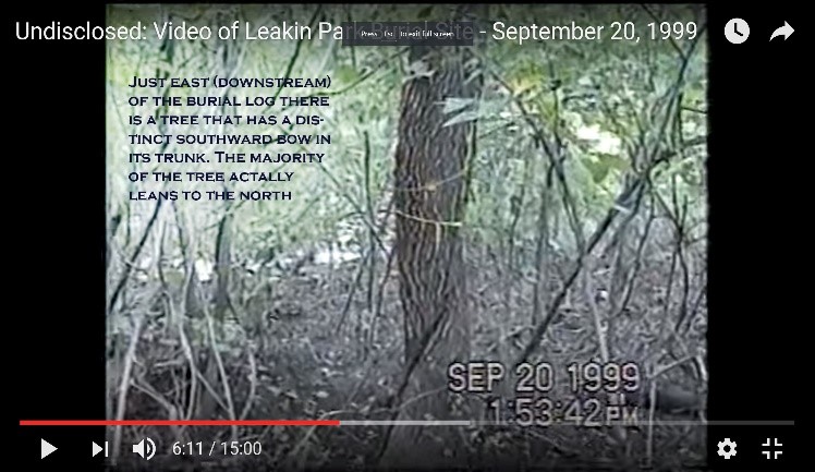
The next marker is even more interesting than the first. Without the convenient rock garden to anchor our mental map of the root end on the 1999 burial log, one has little choice but to rely upon vegetation for landmarks. This task is complicated by the fact that the Dead Run is prone to dramatically escaping from its channel and flooding the crime scene. Fortunately, there is one particular tree in the Dead Run Valley that hosts a persistent clue to its presence at the 1999 burial ground. This tree stood at the downstream root end of the burial log. In the original crime scene video, at 0:02:37, we hear Buddemeyer say, “It’s right here…Yep…’cause I marked the tree.” Just seconds later we see Buddemeyer facing a large tree that is leaning at a severe angle. He appears to be pointing out this tree to Gutierrez.

https://beaucons.com/wp-content/uploads/2016/12/Buddemeyer points to tree.mp4
Today this tree is no longer standing but has collapsed and broken into three section. More on this later, but now that we have set the downstream landmarks. In the image below, you can see Buddemeyer pointing to the burial log and the leaning tree is just downstream from the root end.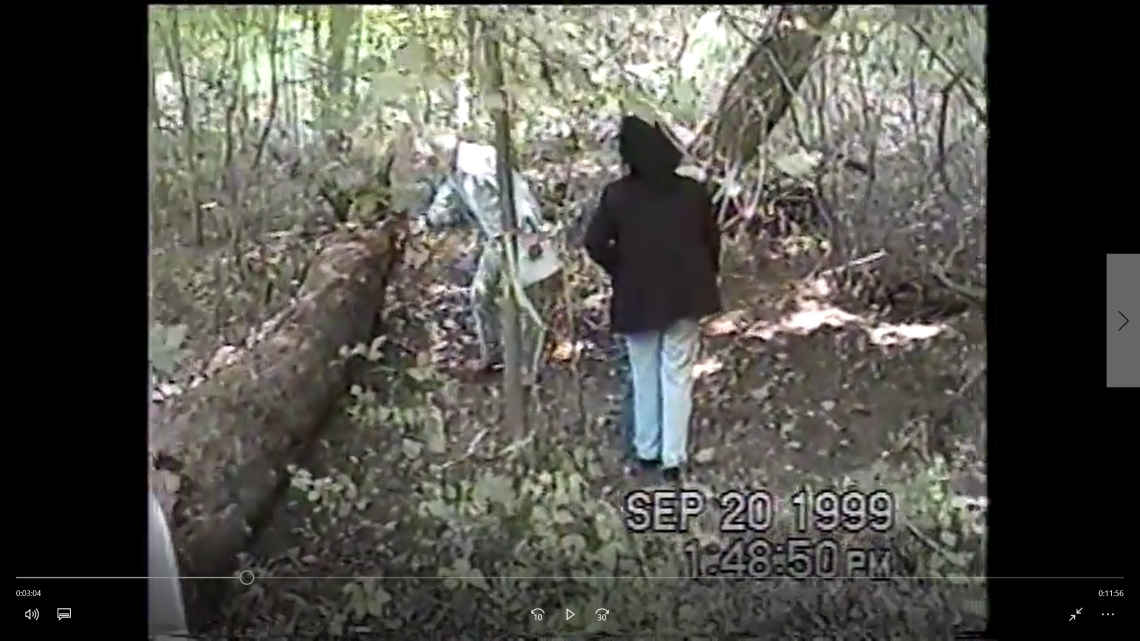
So now, let’s look upstream from the log for markers. In doing so, we once again need to examine the pictures that started this inquiry. It seems that these are two views of the same tree. A patch of significant rot is visible at its base. During my recent visit, I took the following shot:

The same patch of rot is still there.

This screen captures illustrate the relationship of the beech trees to the burial log.
This beech tree was located roughly 12 to 15 feet upstream from the table rock. The following shot illustrates the relationship between and the beech the table rock as of October 6th 2016. In it, you can also see the location of the 2015 burial log as well as the crooked tree. In the original Gutierrez video, this same crooked tree can be seen growing centered on the downstream side of the 1999 log.

One would expect all the landmarks from the 1999 video, the table rock, the leaning or split tree, the twin trunk beech, and the crooked tree to remain, in 2015, in relative proximity to their position in 1999. Realizing the unstable nature of the landscape a reasonable person must also allow for the possibility that things could be significantly rearranged during the intervening year. However, it would require a whole new level of magical realism to explain how a rotting log can reverse its decomposition, increase its girth and relocate more than 60 feet upstream from its original resting place. It makes far more sense to assume that the 2015 Burial log is not the same as the 1999 burial log.
This obviously prompts the question, “So where the hell is the 1999 log?”. You may be surprised to learn that it shows up in at least two of the pictures above. Here’s a hint. The original log has moved some. Not upstream, but about 10 feet or less downstream. What has confused the search is the extent that other things in the valley have moved in 15 years.
Before we get into the exact location of the 1999 burial log, let’s just clear up the situation of the leaning or split tree we saw at the downstream root end of the 1999 log. If you were to visit the burial grounds today, you would not find a standing tree in that spot anymore. Instead, you would find a log that you might at first confuse for the actual burial log. In fact, Rabia and her friends walked up to that very log and wondered out loud if this was the correct log. At 0:01:14 in the Finding the Log Video, the trio approaches the log and her friend asks, “This is the log?” and after a long pause, Rabia answers in a voice full of confusion and surprise, “You know…No…Wait a minute the log is…”.

I can sympathize with their predicament, because I stood in that very spot and asked the same question on October 2, 2016. Unlike Rabia, however, I had brought a metal detector with me. On a previous visit, I had scanned what seemed like every standing tree in the area looking for a PK Nail, a specialized nail used by surveyors. In between visits, I had figured out what the hell Buddemeyer had been talking about, when he said, “Yep…I marked that tree”.
And by the words, “I had figured out”, I mean “Creuset had led me by the nose to the realization of…”. Honestly, I had never even heard about PK nails until she started tutoring me. But on my second trip, I knew there was one more tree to scan. I had missed it last time because I was looking for a tree when I should have been looking for a stump.
During the years between 1999 and 2015, gravity, has changed me to the point that I am almost unrecognizable from my former self, yet I had forgotten to account for this most constant of all friends. On my visit on October 2nd, I was no longer confused. Taking my trusty metal detector, I walked over to the hulk in three parts, that used to be the leaning tree, and waved the business end over the standing stump. Right, where one would expect to find a mark, placed conspicuously on a tree, the detector began to ping with the unmistakable sound it makes to indicate the sensor has passed over metal. Searching the area visually, I could not find a trace of the PK nail, but as far as I was concerned, I had the truth of the matter. This was the leaning tree that Buddemeyer used as a convenient marker so he could find the spot on a return visit. The mold and moss that had once tried to claim the remains of Hae, had had more than a decade and a half to cover up the surveyor’s meager effort to memorialize the spot, but I knew that I was standing just downstream from the root end of the burial log. And, off to my right, I could see one more easily recognizable landmark. That helped complete the big picture.
In the original video, one can see a tree with a markedly crooked trunk growing midway between the roots and the crown end and just downstream of the 1999 log.
That same tree is still there today.
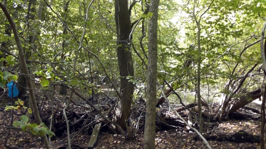
All of my mucking about in the Dead Run Valley led me to believe that the burial log in question should be found upstream of the table rock, the split stump, and the crooked tree and downstream of the beech tree. Not surprisingly, that is exactly where I found it. What may surprise you is that burial log has appeared in at least three of photos above. This is not to suggest that it is hiding in plain sight. Instead, it would be more accurate to say it is camouflaged before our very eyes.
Over the years, a series of floods has roared through the valley sweeping debris along its path. During that time, because it was in full contact with the ground, the burial log has acted like a dam, trapping that debris on its upstream side, until several things happened. First, this additional collection of detritus acted as a blanket, trapping moisture against the log and facilitating additional decay. Next, the additional mass of the debris in addition to the huge volume of flood water and the effects of the rot, eventually caused the log to collapse at its center creating a v-shaped arrangement of the crown end and the root end with the center of the v pointing downstream. It also caused the log to shift downstream about 10 feet or so to coming to rest in its current position. Finally, the pile of refuse grew to the point where it overtopped the log and began to fill in on the downstream side. Consequently, the burial log is now effectively invisible to anyone who was not specifically looking for it, but it remains are still visible if one looks closely. I don’t expect anyone to see the log in the photo below. I have just included it so you can see the other landmarks and understand how so many people would just walk right past the most important log in the entire saga.
Crooked tree in context
I first found the log at about the same time I found the table rock. If you look at the photos above labeled Table Rock V4 above, you can clearly see the remnants of the crown end of the log. The rock is position right next to where the crown section has broken away from the root section of the now two-part burial log. You can see it better in this shot below. By the way, all the blue bags you see were placed by me to identify the various landmarks. I took them all with me when I departed. Sadly, I had to leave all the other debris.

Another look at our above picture, Crooked tree in context, shows the area marked by yellow lines that show where the root end of the log is mostly buried under the debris.

As of October 2016, it is getting more difficult to determine where the log ends and the soil begins. If you look to each side of where I cleared off the mold and trash, you can see the how the log looks when it is uncovered. In the middle, you can see a more solid log. After I kicked away some debris to expose the hidden log, I took a measurement of the remnant. It measured about 14 inches.

Having spent considerable time and energy investigating the location of the 1999 burial log, I can say with confidence that it remains very close to its original location, just about 10 feet or so further downstream and no worse for the wear than can be expected of a log that was substantially deteriorated when first identified. In doing this research, I also learned what I believe might be the most useful lesson from all this tromping around in a less than attractive valley.
I first came to Leakin Park looking for the log where Hae Min’s body had been so unceremonially buried by her killer. Armed with information from a supposed expert, Buddemeyer, who had been prodded into action by the local news media, The Sun, it didn’t take me long at all to find just what I was looking for, the wrong suspect. I then proceeded to document my findings, all the while ignoring perfectly obvious, discrepancies between my suspect and the actual 1999 burial log. It wasn’t until a sufficiently skeptical and observant person pointed out all the things that I had overlooked, that I began my search again. This time free from preconceived notions and committed to following just the facts. I found the true culprit if a log can be described as such. To me, this one little exercise has become a minor metaphor for the entire tragedy of Adnan’s false conviction and incarceration. What impresses me most is the fact that I should have been especially on guard for just such a mistake. I went looking for the log long after having already learned about the problem of confirmation bias, and I still fell victim to the same logic trap. This time, though, I was part of a community of skeptics, people with nothing to gain but the truth, people unfettered by all the conflicting pressures that were on the police and prosecution. Although this new perspective does not permit me to condone the reprehensible behavior of the people who are sworn to protect us, especially the young and the vulnerable among us, it does open my mind to insights that might one day lead to forgiveness of those who rushed to judgment, just not yet. Of course, forgiveness is not something to be proffered unbidden. To receive forgiveness, one must first ask for it. Even an atheist knows that. So, the question now is whether Adnan’s persecutors will ever seek forgiveness.

Congratulations to you and Creusetcontroller for some fantastic teamwork solving this puzzle. I can’t wait to read what you have to say about other provable evidence in the case.
LikeLike
This is very interesting! Well done.
Question: I have often seen people wonder if the parking spot is the only access to the burial spot. Are then any other access routes, and what would you say the likelihood of someone using a different access point would be?
LikeLike
I know early on, people were wondering about the creek as a potential avenue of access. This is an appealing alternative, especially when we know that the water in Dead Run can get pretty deep, but it can also get pretty shallow. Remember that the geologically Leaking Park is on the what they call the fall line, the region that separates the tidal flood plain from the Piedmont. One of my ancestors operated a mill there, long before it became a park. Like any other mill owner, he located near a swiftly flowing year round stream. Because the area drains so well, the water level rarely remains reliably deep enough to consider it as preferable to a land route, if you are considering a canoe or something like that. Wading from the bridge to the burial spot in January, with a corpse doesn’t seem too appealing either. In my opinion, a water route doesn’t offer any advantages over any land route that would justify the inconvenience and risk. The same is true for any other access route. There would need to be a good reason to chose any route substantially different from the one taken by Guttierez and Buddemeyer in the 1999 video.
All the proposed burial scenario that I am aware of presuppose a nighttime burial. This makes perfect sense. Franklintown Road is an unusually dark and narrow lane with nearly no place to pull over safely. The one exception is at the corner of Franklintown and Winans Way. Right there is an area where you can pull off. It seems like this was created over time by necessity, by drivers deciding that, while it wasn’t great, it was better than any other option. Now days, it really is the only sane place anyone would park for any time. In fact, the first time I went to the park at night, to check to see if I could “count change”, I ended up pulling into that very spot. This was before I knew where the burial site was. In the 2015 Buddemeyer video, when you see him pacing off the distance from the corner to the parking area, he starts right at that lone parking spot. In my opinion, the most likely scenario goes like this. A lone villian would approach the parking area by coming west from the intersection of Franklintown and Winans. This would put him on the correct side of the road when he got to the jersey walls. He would then back into the parking area by the jersey barriers. At the time of Hae’s death, this was possible, but is is not now. By leaving his headlights on, he would be able to create such a light imbalance that, for all intents, his trunk and everything around it would be invisible. In a matter of seconds, he could jump out, dump the body on the dark side of the barrier, jump back in and then pull out onto Franklintown Road heading east. In a few hundred yards, he could pull into the parking spot at the corner and then trot back up the road to retrieve the body and carry it deeper into the woods. Anybody seeing his car would have their attention drawn away from where the evil was actually under way.
Personally, I can’t believe it happened substantially differently from what I just described. Any other option introduces more problems with no conceivable advantage. What I like best about this scenario is, it doesn’t require or even benefit from an accomplice.
LikeLike
So there were/are two potential park up spots in fairly close proximity to each other near the burial site?
I’m in complete agreement about a canoe being an unlikely scenario.
1 you need a canoe and roof rack. Putting a canoe on or off a car requires two people.
2 driving along a road with a canoe on the roof in darkness would attract attention, especially when unloading, not what you want when trying to dispose of z body!
3 canoes and rowing boats can be unstable. Loading or unloading a corpse on / off a canoe / rowing boat would be extraordinarily difficult – acorpse on top of a canoe would also be inherently unstable.
4 The murderer and Hae’s body would almost certainly become wet and caked in mud potentially leaving plenty of clues and attracting attention to the murderer when seen by other people afterwards.
5 Dead Run would be treacherous to row / canoe along.
6 it would be very difficult to spot the unloading / moring site from the river in the dark. The murderer would have to be extraordinarily familiar with the site at night from the river to consider this an easy way to carry z body to a burial site accessible from the road.
I can think of more reasons but IMO those, and your explanations, likely rule that option out.
LikeLike
Yes, here is a poor quality image taken with a telephoto lens from the south side of Franklintown just across from the Jersey Barriers. You can see my car in the lower right hand corner.
LikeLike
Were both pull ins there in 1998?
LikeLike
The parking area certainly was there in 1998, although it was configured a little differently. I can’t answer about the parking spot with any certainty. The best I can do for now is suggest that you look at the intersection in Google Earth and then use the historical tool to see the same area over time. The image quality degrades as you go back in time until you get to 1994. In that view, which I think is derived from aerial photos of the region as opposed to satellite imaging, you can see what could easily be interpreted as the parking spot. I am of the opinion that this pull-off is an expression of the will of the people.
It reminds me that of how developers always say about new developments, “Plant grass and then wait where it gets walked to death, then build sidewalks.” Of course, they can’t get away with that but if you have ever seen a development with nice new sidewalks connected by dirt paths where people insist on following the path of least resistance you understand the principle I am referring to.
I’ll try to remember to ask one of my old friends who lived in the area if he can recall that pull-out from his younger days, but for now, this is the best I can do.
I am new to this blogging business. Will you please let me know if you are automatically notified when I reply?
LikeLike
Thanks B. This is my response to your email alert.
I’ve just ‘driven’ the route you suggest (thank you Google maps!,). The park up spots are close to each other. That would be a clever distraction strategy easily accomplished. It does imply planning though but, of course, spur of the moment ideas can be great too.
1. You suggest that, at the drop off point, the front car lights effectively made the trunk invisible by creating a light imbalance.
The Nissan manual Creuset has obtained shows that some models have trunk lights and, of course, if the front lights were on then the rear lights would also be on. In addition, the manual shows there is a trunk lid mounted stop light. So, whilst I accept that the front light would be much more powerful and distracting to a passing motorist, the rear would not be invisible. Of course, the driver would have advance warning of any approaching traffic from the noise and lights and, in those circumstances would be able to stop what he was doing or hurry up and try to finish the duping as fadt as possible. Personally, I wonder if the lights turned off the car would be a safer bet as approaching traffic would not see the vehicle until the last minute. Nothing would be lit up so approaching drivers would not have time to adjust their eyes and check to see if everything was OK. But tbh Idk which scenario is most likely. Either way, I’m sure you’re right about the murderer dumping her body in the general area of her burial site and then returning to bury her later.
2. Sunset, on 13 January 1998 in Baltimore took place at 5.05 GMT. That, in the UK at least, is peak rush hour traffic so would be a risky time to stop and dump a body.
3. Hae was last seen at approximately 2.30. You seem to be suggesting that Hae was dumped over 2 to 2.5 hours after her murder. I wonder what the impact of that time line would be on lividity which can start, in normal people, 30 minutes to 1 hour after death.
http://www.forensicpathologyonline.com/e-book/post-mortem-changes/post-mortem-hypostasis
LikeLike
“So, whilst I accept that the front light would be much more powerful and distracting to a passing motorist, the rear would not be invisible.”
You are probably right.
“Sunset, on 13 January ”
I don’t believe the burial happened in the early evening of Jan. 13. That does not fit with the lividity evidence, which is described as fixed frontal on a corpse which was buried on its side. This would seem to indicate that the body was buried after lividity was fixed. Based on lividity alone, I don’t believe it is possible to say with any confidence that Hae’s body was buried on the 13th. While that is a distinct possibility, lacking any definitive evidence indicating the time of death, it seems just as likely that the burial occurred within several days or more of Hae’s disappearance. However, if one believes that the body position, was influenced by the state of rigor mortis at the time of committal, which is debatable, the time window would be limited to no later than early AM on the 14th.
I believe we are both in agreement that Adnan did not murder Hae. Therefore, I would not recommend committing to assumptions that cannot be proven to a fairly high level of certainty. To do so may inadvertently eliminate potential suspects. I haven’t seen evidence to convince me that the body position described in detail on other websites was not primarily influenced by the nature of a hastily prepared grave, so I am inclined to consider the longer time window as a more useful assumption.
Of course, for the most part in this comment, I am just passing on information developed by others. The only thing I know from my own hands-on investigation is what the area around the burial site looks like now.
LikeLike
I see! I misunderstood you n thought you were suggesting she first got dumped (poor girl) early evening. Gotcha.
I agree about not committing to assumptions. That’s why it took so much work to prove ‘the’ log wasn’t ‘the’ log!
I also believe Adnan is innocent.
LikeLiked by 1 person